
Customer rating
Hotel Garni Forelle
59 Number of reviews:
98 % Recommendation rate:
Accommodation
9.4
Resort
9.3
Ski area
9.6
Piste Map

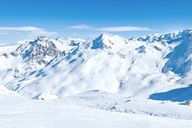
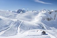
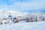
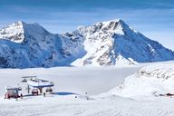
Information about the ski area
Hintertux Glacier
| Highest point: | 3,250 m |
| Lowest point: | 1,500 m |
| Altitude ski resort: | 1,281 m |
| Lifts in total: | 19 |
| Gondola lift: | 6 |
| Chair lifts: | 6 |
| Tow lifts: | 7 |
| Pistes in total: | 64 km |
|
Pistes:
|
17 km |
|
Pistes:
|
35 km |
|
Pistes:
|
12 km |
Weather & Snow report Tux
Are you looking for information about the current snow conditions? Updated weather forecasts for the next few days for Tux can be found here. Often there is also the possibility to view the area via webcam. Further, the active lifts for the ski area of Tux, as well as as the current snow levels on the mountain and in the valley are shown. The diagram also displays a comparison to the previous year's snow levels and supplies an overview for the entire season in Tux.
| Snow depth valley: 0 cm | Ski lifts open: 11 / 20 |
| Snow depth mountain: 305 cm | Pistes open (in km): 9 / 64 |
| Last snow fall: 04/29/2026 | Toboggan run open: n/a |
| Snow condition: Compact powder snow | Snow park open: No |
| Winter hiking trails: 0 km | Valley run open: No |
Snow report
mountain
valley
Web cams
Weather forecast
|
Today
07/18/26 |
Tomorrow
07/19/26 |
Mo
07/20/26 |
Tu
07/21/26 |
|
|---|---|---|---|---|
| 5 days forecast | ||||
| Min. / max. temp. | 2 / 3 °C | 0 / 2 °C | 0 / 1 °C | -3 / -2 °C |
| Hours of sunshine | 11 h | 10 h | 10 h | 6 h |
| Fresh snow | 2 cm | 7 cm | 2 cm | 3 cm |
| Snowfall line | 3,200 m | 3,100 m | 3,000 m | 2,500 m |
|
Morning |
Midday |
Evening |
Night |
|
|---|---|---|---|---|
| Temperature | 3 °C | 3 °C | 2 °C | 2 °C |
| Wind speed | 30 km/h | 20 km/h | 30 km/h | 25 km/h |
| Fresh snow | 0 cm | 0 cm | 2 cm | 0 cm |
| Snowfall line | 3,300 m | 3,400 m | 3,200 m | 3,200 m |
|
Morning |
Midday |
Evening |
Night |
|
|---|---|---|---|---|
| Temperature | 2 °C | 2 °C | 0 °C | 1 °C |
| Wind speed | 20 km/h | 20 km/h | 35 km/h | 35 km/h |
| Fresh snow | 0 cm | 3 cm | 4 cm | 0 cm |
| Snowfall line | 3,200 m | 3,200 m | 2,900 m | 3,000 m |
|
Morning |
Midday |
Evening |
Night |
|
|---|---|---|---|---|
| Temperature | 0 °C | 1 °C | 0 °C | 0 °C |
| Wind speed | 30 km/h | 20 km/h | 15 km/h | 25 km/h |
| Fresh snow | 0 cm | 0 cm | 1 cm | 1 cm |
| Snowfall line | 2,900 m | 2,900 m | 3,000 m | 2,800 m |
|
Morning |
Midday |
Evening |
Night |
|
|---|---|---|---|---|
| Temperature | -3 °C | -3 °C | -3 °C | -3 °C |
| Wind speed | 25 km/h | 25 km/h | 30 km/h | 30 km/h |
| Fresh snow | 0 cm | 1 cm | 1 cm | 0 cm |
| Snowfall line | 2,400 m | 2,500 m | 2,500 m | 2,300 m |
|
Today
07/18/26 |
Tomorrow
07/19/26 |
Mo
07/20/26 |
Tu
07/21/26 |
|
|---|---|---|---|---|
| 5 days forecast | ||||
| Min. / max. temp. | 11 / 19 °C | 9 / 17 °C | 8 / 16 °C | 8 / 13 °C |
| Hours of sunshine | 8 h | 9 h | 10 h | 3 h |
| Fresh snow | 0 cm | 0 cm | 0 cm | 0 cm |
| Snowfall line | 3,200 m | 3,100 m | 3,000 m | 2,500 m |
|
Morning |
Midday |
Evening |
Night |
|
|---|---|---|---|---|
| Temperature | 14 °C | 17 °C | 14 °C | 11 °C |
| Wind speed | 0 km/h | 5 km/h | 5 km/h | 0 km/h |
| Fresh snow | 0 cm | 0 cm | 0 cm | 0 cm |
| Snowfall line | 3,300 m | 3,400 m | 3,200 m | 3,200 m |
|
Morning |
Midday |
Evening |
Night |
|
|---|---|---|---|---|
| Temperature | 12 °C | 14 °C | 11 °C | 9 °C |
| Wind speed | 0 km/h | 5 km/h | 5 km/h | 5 km/h |
| Fresh snow | 0 cm | 0 cm | 0 cm | 0 cm |
| Snowfall line | 3,200 m | 3,200 m | 2,900 m | 3,000 m |
|
Morning |
Midday |
Evening |
Night |
|
|---|---|---|---|---|
| Temperature | 9 °C | 15 °C | 13 °C | 9 °C |
| Wind speed | 0 km/h | 5 km/h | 5 km/h | 5 km/h |
| Fresh snow | 0 cm | 0 cm | 0 cm | 0 cm |
| Snowfall line | 2,900 m | 2,900 m | 3,000 m | 2,800 m |
|
Morning |
Midday |
Evening |
Night |
|
|---|---|---|---|---|
| Temperature | 9 °C | 12 °C | 10 °C | 8 °C |
| Wind speed | 0 km/h | 5 km/h | 5 km/h | 0 km/h |
| Fresh snow | 0 cm | 0 cm | 0 cm | 0 cm |
| Snowfall line | 2,400 m | 2,500 m | 2,500 m | 2,300 m |
Climate
- Hours of sunshine
- Snow fall (cm)
- Snow days
| 2025 | 2026 | ||||||||||
|---|---|---|---|---|---|---|---|---|---|---|---|
| Jul | Aug | Sep | Oct | Nov | Dec | Jan | Feb | Mar | Apr | May | Jun |
| 6 h | 8 h | 6 h | 6 h | 5 h | 5 h | 5 h | 4 h | 6 h | 8 h | 8 h | 9 h |
| 124 | 91 | 107 | 107 | 165 | 24 | 82 | 184 | 171 | 42 | 142 | 111 |
| 11 | 8 | 16 | 9 | 10 | 4 | 9 | 15 | 16 | 8 | 14 | 13 |
Weather data source:© GeoSphere Austria
Snow data source: Skiresort